2022 - Today
URBAN PLANNING AND INFRASTRUCTURE IN MIGRATION CONTEXTS
UN-HABITAT

For more than a decade, Cameroon has been hosting internally displaced persons and refugees, whose numbers have increased in the last five years due to internal and external crises fuelled by religious and political grievances i.e., Anglophone crisis, Boko Haram, instability in Central African Republic (CAR). Cameroon currently hosts CAR refugees, Nigerian refugees, urban refugees, and asylum seekers of various nationalities, and IDPs.
Since the resurgence of the conflict in 2015-2016, the increase in the displacements of people to the Littoral region, particularly to Douala, has been observed. As the conflict has become entrenched, the massive influx of populations has been concentrated in Douala 4, which borders the NOSO area. The subdivision of Douala 4 has faced several challenges in meeting the needs of the growing host population and the arrival of IDPs. The exponential demographic growth combined with the pressure on facilities, have led to an uncontrolled urban expansion of the subdivision without good urban planning.
In response to the situation, UN-Habitat, funded by SECO, aims to improve access to reliable services and socio-economic opportunities for displaced populations in Douala through the “Urban Planning & Infrastructure in Migration Contexts Programme”. As a first step, this Spatial Profile was developed for Douala city to improve the spatial understanding of the existing situation. Using a participatory approach, challenges, provisions, and gaps in public infrastructure services were identified and mapped, and presented at the national, regional, and local scales. Charrettes to validate data were organised, and technical committees for consultation were created. The pilot neighbourhood of Mambanda was selected to be detailed further through recommendations in the Visioning and scenario building stages coming up.
PUBLICATIONS
2024 – Profil Urbain Douala 4 (French)
2023 – Vision, Scenario Building, and Action Plan for the subdivision of Douala 4
2022 – Douala 4 Spatial Profile (English)
2021
ANGERVILLE, A NEW GROWTH MODEL FOR THE SMALL TOWN
Winner of the 2021 Award “Small-sized cities of tomorrow”
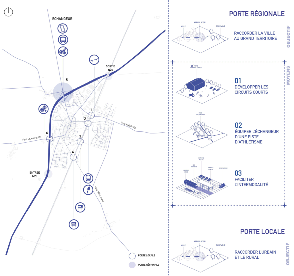
This project focuses on the development of Angerville, located in the South of the Essonne. Halfway between Paris and Orléans, it offers the charms of a town in the countryside. However, subject to the effects of Parisian growth, it is showing signs of decline. The neglect of the old town center, the estrangement from the countryside and the urban/rural divide are major issues. How can Angerville counteract these forms of drift? What urbanity for tomorrow?
This project aims to develop a new model of growth to address the urban decline affecting Angerville. This model is based on the following 5 principles:
• Reconnecting with the territory – an urbanity that reveals the specificities of the territory, respectful and aware of the place.
• Reduce the urban-rural divide – a reborn urbanity to reconcile the urban fabric with the rural territories.
• Controlling urban growth – an urbanity that respectful of its environment and not in a power struggle with rural areas.
• Fostering citizen participation – a collective urbanity to ensure cohesion and reduce social fractures.
• Developing an active soil – an urbanity that weaves bonds between humans and their surrounding environment.
2020
ZIP – ZONE FOR INCLUSIVE PROGRESS
UIA2020Rio Competition, project highlighted
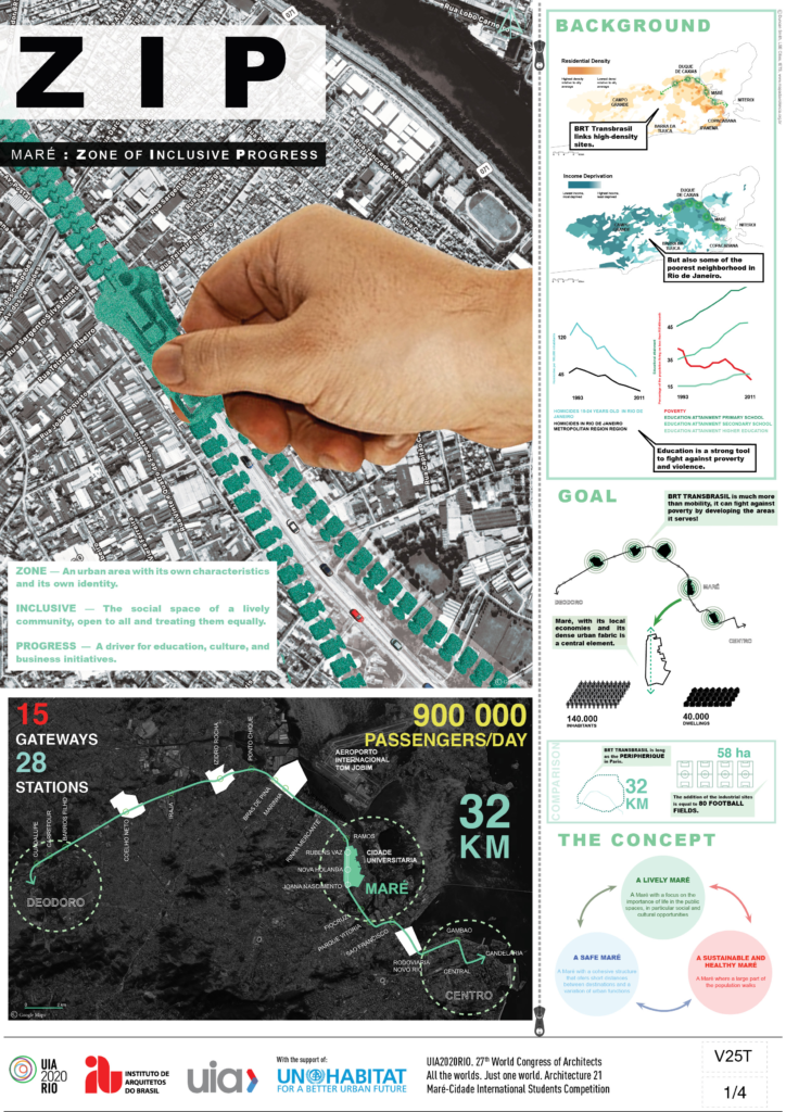
The famous thoroughfare expressway Avenida Brasil, divides the city of Rio de Janeiro on more than 55 km. The launch of the BRT Transbrasil will reconnect West suburbs and the city center, but leaves unaddressed the connection of neighborhoods on its route such as the Maré.
Maré is less a deprived area than one of unexploited potential. Using the dynamics of new transport infrastructures to their full extent will revive the neighborhood and enhance social cohesion, develop local economies, and create a new urban identity in Rio.
Fostering smart and universal mobility. ZIP will bring together the different means of transport to provide an easier access to all users and develop interconnectivity.
Improving the quality of urban spaces. ZIP will revitalize 5 sites across the Avenida, selected for their strong industrial identity.
The Maré is a major hub, known for its retail trade, active communities and vibrant cultural life.
Creating resilient infrastructures for all. Rehabilitating buildings and making them available to the inhabitants of the Maré will increase their participation in community life and local decision-making.
ZIP will bridge the two sides of the Maré and reshape the neighborhood in the long run. Building on the strong identity and assets of the Maré, the project will enhance inclusive and sustainable urbanization. It is a promising practice for the cities of tomorrow, demonstrating that a city can address poverty and inequality, while committing to climate action and sustainable communities, in direct support of the UN Sustainable Development Goals (SDGs).
2019
The Olympic and Paralympic Village – Paris 2024
DOMINIQUE PERRAULT ARCHITECTURE
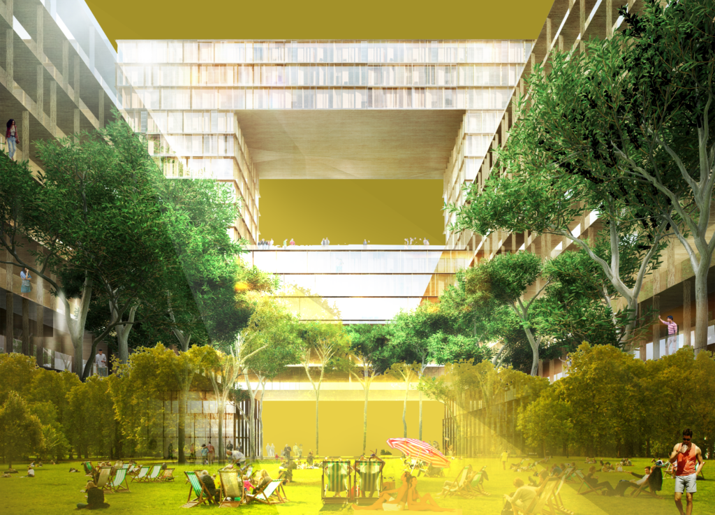
The future of the Olympic Village needs to be considered on a dual scale: the project aims to improve interaction with its immediate environment and the metropolis by building on the existing infrastructure as much as possible. The preliminary design of the public spaces was based on the following guiding principles:
- The district’s central position in the Greater Paris area, and its location in relation to the Seine.
- The challenges of integrating the project into the existing urban and social fabric.
- The ambition to make the village a laboratory for sustainable innovation (environmental sustainability, preservation and development of biodiversity, universal accessibility, etc.).
The project aims to address the issue of landmarks and the identity of public spaces during the games but is also concerned with developing a high-quality geographical and geological heritage over the long term.
2019
The Man 24 Hour Race Park
DOMINIQUE PERRAULT ARCHITECTURE

At a time of ecological collapse and global warming, how can we reconcile an emblematic park, a large pedestrian sports loop, the occasional reception of nearly 250,000 visitors, with commitments to sustainability that respect the environment on this 950-hectare territory inside the legendary 13.6 km racetrack? We have taken up the challenge of transforming this site into a sustainable and accessible destination to all and all year round.
This is an ambitious project that would transform the 24 Hours of Le Mans circuit into:
- An urban park that would link the circuit to the surrounding sports facilities through a large sports loop.
- Soft mobility and pedestrian areas for visitors to support the emergence of electricity and hydrogen as clean fuels for motor racing.
- An urban ecosystem that respects its environment, and which relies on renewable energies and sustainable water management.
2018
GUARDERIA PASITOS VERDES
ARCH-SHARING COMPETITION
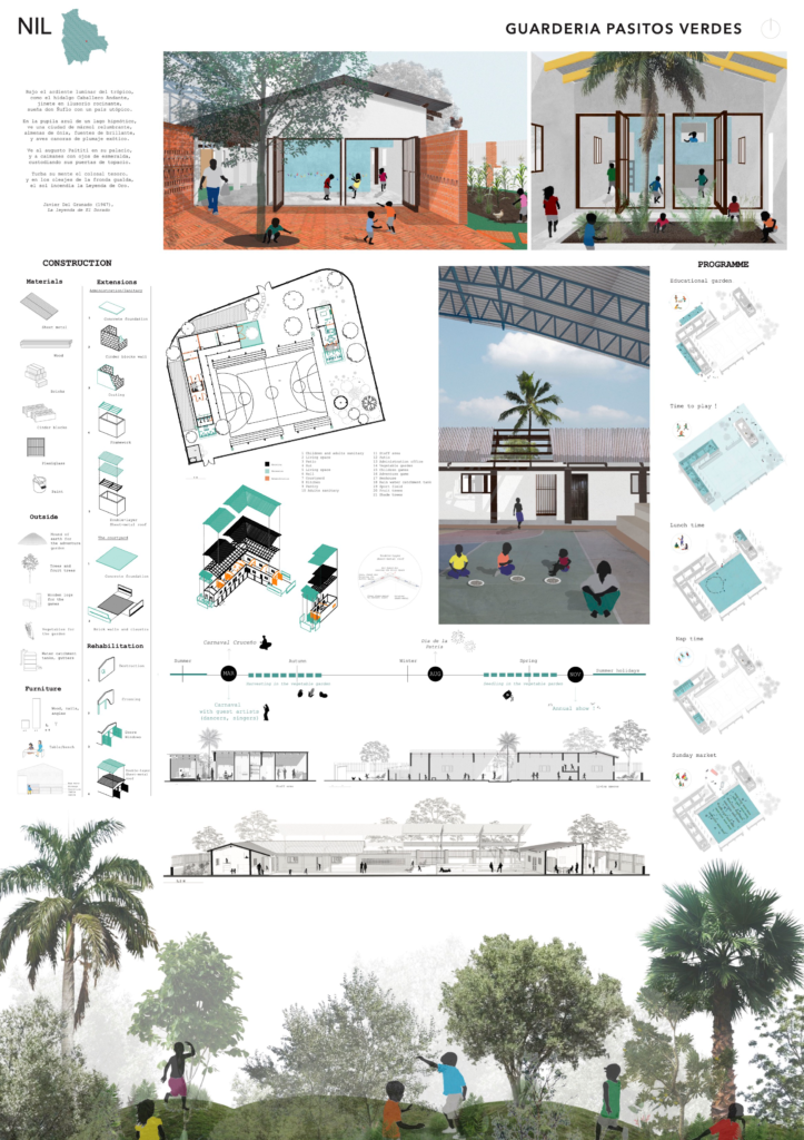
This project is the bearer of human, social and ecological values. The uses partition the plan: the West wing, with two flexible spaces, is designed for the children, while the East wing houses the staff area. In warm weather, the double-layer roof and two patios refresh the air, as do the many trees in the garden. The children stimulate their creativity by playing outside on the adventure trail. The creation of a vegetables garden, a henhouse and rainwater catchment tanks allow them to be aware of environmental issues on a daily basis.